| Bideford Weather Data |
|---|
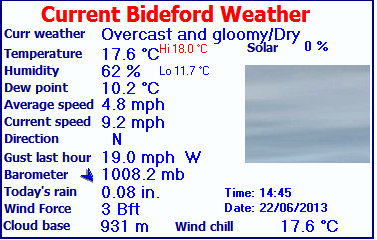
| LAST READING AT TIME: 14:45 DATE: 22 June 2013, time of next update: 14:46 |
|---|
| Current Weather | Overcast and gloomy/Dry |
Current Temperature | 17.6°C (63.7°F) (Heat Index 17.6°C ), Apparent temp 16.3°C , Apparent temp solar 16.3°C |
| Maximum Temperature (since midnight) | 18.0°C at: 14:32 |
Minimum Temperature (since midnight) | 11.7°C at: 00:08 |
| Average windspeed (ten minute) | 4.8 mph |
Wind Direction (ten minute) | SW (236°) |
| Windchill Temperature | 17.6°C |
Maximum Gust (last hour) | 19.0 mph at: 13:48 |
| Maximum Gust (since midnight) | 27.3 mph at: 11:48 |
Maximum 1 minute average (since midnight) | 13.7 mph at: 09:13 |
| Rainfall (last hour) | 0.00 in. (0.0 mm) |
Rainfall (since midnight) | 0.08 in. (2.1 mm) at 13:32 |
| Rainfall This month | 0.74 in. (18.9 mm) |
Rainfall To date this year | 13.91 in. (353.4 mm) |
| Maximum rain per minute (last hour) | 0.00 in/min |
Maximum rain per hour (last 6 hours) | 0.04 in/hour |
| Yesterdays rainfall | 0.05 in |
DewPoint | 10.2°C (Wet Bulb :13.7°C ) |
| Humidity | 62 %, Humidex 19.0°C |
Barometer corrected to msl | 1008.2 mb |
| Pressure change | -0.1 mb (last hour) |
Trend (last hour) | STEADY |
| Pressure change (last 12 hours) | -2.1 mb |
Pressure change (last 6 hours) | +0.1 mb |
| Current 00:00 hours of sunshine today, current sky: Overcast and gloomy |
|---|
| Sunshine hours for the year: | 56:04 hrs | Sunshine hours for the month: | 00:00 hrs |
| Current evapotranspiration 0.06 inches per day. Yesterday's reading 0.06 |
|---|
